


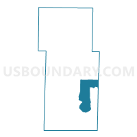
Ruth C Voting District, Stone County, Missouri
About
Outline

Summary
| Unique Area Identifier | 611427 |
| Name | Ruth C Voting District |
| County | Stone County |
| State | Missouri |
| Area (square miles) | 28.02 |
| Land Area (square miles) | 22.68 |
| Water Area (square miles) | 5.34 |
| % of Land Area | 80.95 |
| % of Water Area | 19.05 |
| Latitude of the Internal Point | 36.64708080 |
| Longtitude of the Internal Point | -93.37070510 |
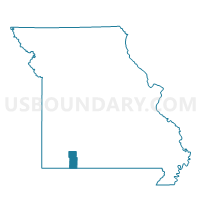
Maps

Graphs
Select a template below for downloading or customizing gragh for Ruth C Voting District, Stone County, Missouri


Neighbors
Neighoring Voting District (by Name) Neighboring Voting District on the Map
- BRANSON 1 Voting District, Taney County, MO
- NORTH BRANSON Voting District, Taney County, MO
- Pine A Voting District, Stone County, MO
- Pine B Voting District, Stone County, MO
- Ruth A Voting District, Stone County, MO
- Ruth B Rural/Kimberling City Voting District, Stone County, MO
- Ruth C Rural/Sunset Cove Voting District, Stone County, MO
Top 10 Neighboring County Subdivision (by Population) Neighboring County Subdivision on the Map
- Branson township, Taney County, MO (18,469)
- Ruth A township, Stone County, MO (4,227)
- Ruth C township, Stone County, MO (3,489)
- Ruth B Rural township, Stone County, MO (3,268)
- Pine A township, Stone County, MO (2,109)
- Pine B township, Stone County, MO (2,086)
- Sunset Cove township, Stone County, MO (705)
- Ruth C Rural township, Stone County, MO (528)
Top 10 Neighboring Place (by Population) Neighboring Place on the Map
- Branson city, MO (10,520)
- Indian Point village, MO (528)
- Branson West city, MO (478)
- Coney Island village, MO (75)
Top 10 Neighboring Unified School District (by Population) Neighboring Unified School District on the Map
- Branson R-IV School District, MO (26,576)
- Reeds Spring R-IV School District, MO (16,588)
- Blue Eye School District, MO (5,399)
Top 10 Neighboring State Legislative District Lower Chamber (by Population) Neighboring State Legislative District Lower Chamber on the Map
Top 10 Neighboring State Legislative District Upper Chamber (by Population) Neighboring State Legislative District Upper Chamber on the Map
Top 10 Neighboring 111th Congressional District (by Population) Neighboring 111th Congressional District on the Map
Top 10 Neighboring Census Tract (by Population) Neighboring Census Tract on the Map
- Census Tract 4802.01, Taney County, MO (9,130)
- Census Tract 4801.05, Taney County, MO (6,529)
- Census Tract 905, Stone County, MO (5,778)
- Census Tract 904, Stone County, MO (5,399)
- Census Tract 906.02, Stone County, MO (5,214)
- Census Tract 906.01, Stone County, MO (3,381)
- Census Tract 4801.06, Taney County, MO (1,943)